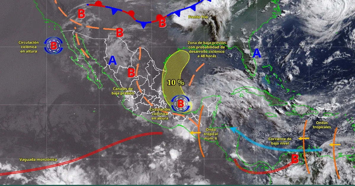
Mexico City — Tropical Wave No. 6 will sweep across southeastern Mexico on Friday, interacting with a low-pressure system over the southwestern Gulf of Mexico and atmospheric instability to produce intense rainfall in nine states, according to the National Water Commission (Conagua).
The system will bring heavy downpours to Jalisco, Puebla, Veracruz, Oaxaca, Chiapas, Tabasco, Campeche, Yucatán and Quintana Roo. Much of the rest of the country will see strong to very strong showers and thunderstorms, accompanied by lightning and possible hail.
Hot to very hot temperatures are expected in northern and northwestern Mexico, as well as the Yucatán Peninsula. A heat wave continues in Sonora, Chihuahua, Durango and Sinaloa, and begins in northeastern Baja California.
Regional Forecast
Valley of Mexico: Morning fog and partly cloudy skies, turning cloudy in the afternoon with very heavy rain in the State of Mexico and heavy rain in Mexico City. Temperatures in the capital will range from 14°C to 27°C. Winds of 10-20 km/h with gusts up to 50 km/h.
Baja California Peninsula: Partly cloudy to cloudy skies with showers in Baja California and Baja California Sur. Hot to very hot in the northeast. Winds of 10-20 km/h with gusts up to 50 km/h. Waves of 1-2 meters on the west coast.
Northern Pacific: Heavy rain in eastern Sonora and northeastern Sinaloa. Very hot conditions persist with the heat wave. Winds of 10-20 km/h with gusts up to 50 km/h.
Central Pacific: Intense rain in western and central Jalisco; very heavy rain in southern Nayarit; heavy rain in Colima and Michoacán. These could cause river rises, landslides and flooding. Winds of 10-20 km/h with gusts up to 50 km/h. Swell of 1-2 meters off Jalisco, Colima and Michoacán.
Southern Pacific: Intense rain in northern, eastern and southeastern Oaxaca and in northern, eastern and southern Chiapas; very heavy rain in northern and northwestern Guerrero. Winds of 10-20 km/h with gusts up to 50 km/h. Swell of 1-2 meters.
Gulf of Mexico: Intense rain in Veracruz and Tabasco; very heavy rain in southern Tamaulipas. Winds of 20-30 km/h with gusts up to 60 km/h in Tamaulipas. Waves of 1-2 meters.
Yucatán Peninsula: Intense rain in western and southwestern Campeche, western Yucatán and southern Quintana Roo. Winds of 20-30 km/h with gusts up to 60 km/h. Waves of 2-3 meters.
Northern Plateau: Very heavy rain in southern and southwestern Chihuahua, northwestern and western Durango, and eastern San Luis Potosí; showers in Coahuila, Nuevo León, Zacatecas and Aguascalientes. Winds of 20-30 km/h with gusts up to 60 km/h in Chihuahua, Coahuila, Nuevo León and Durango.
Central Plateau: Intense rain in Puebla; very heavy rain in Hidalgo, Morelos and Tlaxcala; heavy rain in southern and southeastern Guanajuato and northern Querétaro. Winds of 10-20 km/h with gusts up to 50 km/h.
Authorities urged residents in affected areas to take precautions against flooding, landslides and reduced visibility.