Mexico City — El Niño conditions have officially developed in the tropical Pacific, and forecasters say the event is expected to strengthen into the winter of 2026–2027. While the strongest impacts are usually felt along the Pacific coast of South America, the effects can reach far beyond that region, including the Caribbean, the Yucatán Peninsula, and Quintana Roo.
For the Riviera Maya, the question is not simply whether this will be a “strong” or “Godzilla” El Niño. That phrase is not a scientific classification. The more useful question is how a strengthening El Niño could affect heat, rainfall, hurricane risk, water demand, tourism operations, and coastal ecosystems in a region already dealing with rapid growth and climate stress.
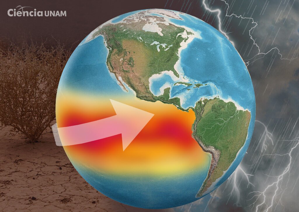
El Niño is the warm phase of the El Niño-Southern Oscillation, or ENSO. It occurs when sea surface temperatures in the central and eastern tropical Pacific become warmer than normal, disrupting atmospheric circulation patterns around the world. NOAA’s Climate Prediction Center says El Niño conditions are now present and are expected to intensify into the Northern Hemisphere winter.
Historically, El Niño tends to suppress Atlantic hurricane activity by increasing vertical wind shear over the Atlantic and Caribbean. Wind shear can disrupt the formation and organization of tropical storms. That is one reason NOAA is forecasting a below-normal 2026 Atlantic hurricane season, with 8 to 14 named storms, 3 to 6 hurricanes, and 1 to 3 major hurricanes.
For Quintana Roo, that may sound reassuring, but it should not be taken as a reason to relax. A below-normal season does not mean a no-risk season. The Riviera Maya only needs one poorly placed storm to cause serious damage. Warm Caribbean waters can still support strong storms, and short-notice systems forming close to land remain a concern. Hurricane planning should continue as usual.
Where El Niño may matter more locally is heat and rainfall. Across parts of the Caribbean, El Niño conditions that develop in summer are often linked to reduced rainfall, fewer heavy showers, and more heat and humidity. For Quintana Roo, that could mean hotter days, warmer nights, higher air-conditioning demand, more stress on the electrical grid, and greater discomfort for outdoor workers, visitors, and residents.
Drier periods can also increase wildfire risk in jungle and roadside vegetation, especially in areas where land clearing, construction, and unmanaged lots already create dry fuel. Even in a coastal state known for humidity, short dry spells can become a problem when they coincide with extreme heat.
Water demand is another issue. Hotels, condos, restaurants, golf courses, and residential developments all rely on steady water access. A hotter and drier season can increase consumption at the same time that ecosystems, gardens, cenotes, wetlands, and mangroves are under stress. In fast-growing areas such as Tulum, Playa del Carmen, Puerto Aventuras, and Cancún, water and infrastructure pressure are already part of the wider development conversation.
The tourism sector could feel the effects in several ways. Fewer Atlantic storms would be good news for travel confidence, but extreme heat can affect visitor experience, outdoor excursions, construction crews, hospitality workers, beach clubs, restaurants, and transportation providers. Heat also increases operational costs for hotels and businesses that depend on air conditioning, refrigeration, pools, landscaping, and water service.
The marine environment is another concern. El Niño years often contribute to elevated global temperatures, and warmer seas can place additional stress on coral reefs. Quintana Roo’s reefs are already under pressure from coral disease, coastal development, pollution, sargassum, storms, and warming water. Additional heat stress can raise the risk of bleaching and weaken reef resilience.
Rainfall patterns are harder to predict at the local level. El Niño can tilt the odds toward drier conditions in parts of the Caribbean and southern Mexico, but that does not eliminate the risk of intense downpours. Warmer air holds more moisture, and when storms do develop, rainfall can be heavy. That matters in urban areas where drainage is limited or where rapid development has replaced natural absorption areas.
This is why the “Godzilla El Niño” label can be misleading. A dramatic name may get attention, but it can also create confusion. El Niño does not produce the same impacts everywhere, and even strong events can behave differently from one year to the next. The better approach is preparation without panic.
For Quintana Roo and the Riviera Maya, that means staying alert to official hurricane updates, preparing for heat and dry spells, watching water use, protecting vulnerable workers, monitoring wildfire risk, and paying close attention to reef and coastal conditions.
El Niño is a Pacific phenomenon, but its reach is global. In the Mexican Caribbean, its biggest local message may be this: fewer storms on paper does not mean fewer climate risks. The risks simply shift.
More Environment
- Grupo Xcaret-Linked Company Seeks $20 Million Purchase Of Dolphin Company’s Mexican Parks
- Mexico’s Conagua Offers Free Water Concession Regularization for Expired Permits
- Activists Denounce Jungle Destruction for Unpermitted Real Estate Project Near Akumal
- Mangroves Recover Ground Worldwide; Quintana Roo Leads Mexico in Protection
- Photo Exhibition Showcases Biodiversity of Tulum National Park