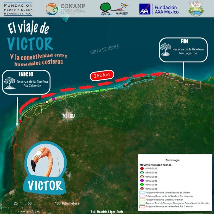
Río Lagartos, Yucatán — A Caribbean flamingo known as Víctor has completed a 262-kilometer journey between the Ría Celestún and Ría Lagartos biosphere reserves in Yucatán, a trek that researchers say underscores how vital the region’s coastal wetlands are to the species’ survival.
The bird is part of an ambassador flamingo monitoring program, and a geotransmitter fitted to its body allowed researchers to reconstruct its route. The recorded data show Víctor made several stopovers in wetlands of the Ciénagas y Manglares de la Costa Norte de Yucatán state reserve and the Bocas de Dzilam state reserve.
Those sites likely served as feeding and resting grounds before the flamingo continued along the Yucatán coastline.
A natural corridor linking wetlands
Beyond the distance covered, the tracking data offer insight into the ecological connectivity between protected areas on the Yucatán Peninsula, where separate ecosystems function as a single territory for wildlife.
While a tidal inlet, a mangrove stand, a salt flat or a coastal lagoon may look isolated to people, for the Caribbean flamingo (Phoenicopterus ruber) they are complementary spaces used for feeding, resting, sheltering and breeding.
Water circulation, the exchange of nutrients and the movement of living organisms keep these environments linked, meaning their conservation must consider not only each individual wetland but also the connections between them.
Protecting one wetland means protecting a network of life
Víctor’s documented route shows that the survival of species depends largely on these natural spaces maintaining their conditions and remaining connected.
The loss or degradation of a single wetland can affect other sites along wildlife migration routes by reducing the space available for feeding, resting and reproduction.
The findings come from a research and conservation program run by the Pedro y Elena Hernández Foundation through its Yucatán Peninsula Program, which aims to deepen knowledge of the Caribbean flamingo and support conservation of the species in Mexico and the wider Caribbean region.
The project is backed by Fundación AXA México and Fundación SíMiPlaneta, organizations that work on environmental education and habitat protection for the bird.
Satellite tracking of birds such as Víctor offers a clearer picture of their movements and provides evidence of the need to conserve coastal wetlands as an interconnected system that is fundamental to biodiversity on the Yucatán Peninsula.
More Environment
- Inside the New Guide to Mexican Caribbean Cave Diving
- Dried Starfish Still Sold in Isla Mujeres Despite Permanent Ban
- Quintana Roo Launches No-Investment Solar Fund to Cut Business Power Bills by 30%
- Playa del Carmen Mayor Under Pressure Over Removal of Two 80-Year-Old Trees in Zazil-Há
- Maya Chicle Still Lacks International Registration Two Years After Geographic Indication