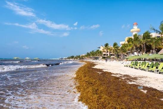
Cancún, Quintana Roo — Sargassum is fouling more than half of the monitored beaches along Quintana Roo’s northern Caribbean coast, with 18 sites reporting excessive accumulation, according to the state’s latest seaweed monitoring map.
The Sargassum Traffic Light Map published by the Quintana Roo Environment and Ecology Department (SEMA), updated on October 9, 2026, covers 100 coastal points. It found 53 with concentrations ranging from moderate to excessive, 44 with low levels and only three completely free of the macroalgae.
Broken down, 18 beaches showed excessive sargassum, seven abundant and 28 moderate. That means 25 percent of monitored beaches carried abundant or excessive seaweed, while 47 percent had low accumulations or none at all.
Tulum and Puerto Morelos
In Tulum, the map flagged excessive accumulation at Arco Maya, Tulum Zona Hotelera Sur, Punta Piedra and Tulum Zona Hotelera Norte. Nearby sites including Tankah, Bahía Soliman, Xcacel-Xcacelito and Bahía Príncipe registered moderate levels.
Puerto Morelos recorded its worst conditions at Puerto Morelos Centro, Puerto Morelos Norte, Punta Caracol and Bahía Petempich. Punta Brava, Playa del Secreto and Playa El Dorado showed moderate buildup.
Cancún’s Mixed Picture
Cancún’s hotel zone and mainland shore showed sharply different conditions. Playa Coral and Playa Gaviota Azul reported excessive accumulation, while Playa Delfines, Playa Ballenas, Playa Marlín and Playa Chac-Mool registered moderate levels.
Other stretches of the resort city fared better, with low sargassum levels at Playa del Niño, Puerto Juárez, Playa Langosta, Playa Tortugas and Playa Caracol. Officials noted the distribution is uneven along the shoreline, even among beaches in the same destination.
Cozumel: East Coast Hit, West Coast Clear
Cozumel showed a clear split between its two coasts. The eastern shore recorded excessive accumulation at Punta Molas, Playa Xhanan, Playa El Castillo, Playa Mezcalitos, Playa Chumul, Playa Chen Río and Mirador San Martín.
The western coast stayed largely clear, with low levels at San Juan, Las Uvas, Chankanaab, San Francisco, Playa Mía, Palancar and El Cielo — a distinction of interest to visitors and tourism operators looking for cleaner water.
Beaches Free of Sargassum
Only three monitored points reported no sargassum: Chiquilá, the Holbox ferry terminal and Isla Contoy. On Holbox, Punta Cocos, Holbox Centro and Punta Mosquito registered low levels, as did several spots on Isla Mujeres, including Playa Norte, Playa Mia, Playa Centro, Playa Lancheros and Punta Sur.
Weather Conditions
The report listed reference weather conditions of temperatures between 24 and 31 degrees Celsius, south-southwest winds of 25 to 35 kilometers per hour and two-meter waves.
The map was produced by hydrobiologist Esteban Jesús Amaro Mauricio and carries the markings of SEMA and other institutions. The data reflects conditions recorded on October 9, 2026, and sargassum levels may shift afterward.
More Environment
- Hurricane Simon Threatens Puerto Vallarta as Category 4
- Mexico’s Environment Agency Rejects Four Major Tourism Projects in Quintana Roo
- Semarnat Denies Environmental Permit for GL Dreams Subdivision in Puerto Morelos
- Caribbean Sargassum Becomes Fertilizer for Global Beer Brands
- Heavy Machinery at Night on Cancún’s Playa Delfines Raises Environmental Concerns
More Quintana Roo
- Quintana Roo Tops Mexico’s Human Trafficking Cases, Sheinbaum Warns
- Buen Fin 2026 Set for November 13-17 With Five Days of Deals in Cancún
- IMSS Launches Winter Vaccination Drive in Quintana Roo With 263,000 Doses
- Morena Ratifies Gino Segura as Quintana Roo State Coordinator
- Mexican Caribbean to Lose 435,000 US Airline Seats by End of 2026