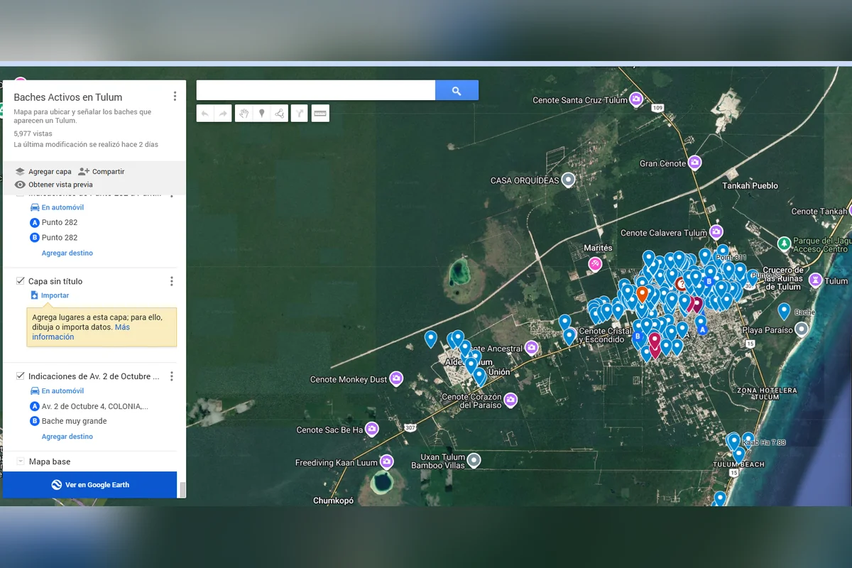
Tulum, Quintana Roo — Residents of this Caribbean beach destination have logged more than 400 road defects on an interactive map, documenting the potholes and sinkholes that spread across town after heavy rains and utility works.
The tool, built by members of the citizens’ group Tulum Unido, has recorded over 400 damaged spots in the municipal seat and drawn nearly 5,700 views within a week of being shared on social media.
A map born from the rain
Efraín Alavez Huerta, a lawyer with a master’s degree in land-use planning and 15 years of experience in urban and environmental consulting, is one of the project’s authors.
“It came out of the first rains we had at the start of this month. It rained suddenly and potholes started forming everywhere,” he said. “So I said, let’s see how we can help people visualize and grasp the scale of the pothole problem. We started building this little interactive map so that Tulum’s residents can mark where their potholes are, so the municipality can see and understand the scale of the problem.”
The project formally launched in early October, driven by rain damage and by disruptions linked to public works. Its developers pointed in particular to sinkholes and cuts in unpaved dirt roads left by pipe-installation work carried out by the Potable Water and Sewer Commission (CAPA), which turned into trenches and potholes up to a kilometer long on several streets in the urban area.
Built on Google Maps, the platform lets residents drop the exact location of damage themselves. In its first 48 hours it registered more than 300 entries. While the catalogue also includes trenches and flood-prone areas, the vast majority of reports are potholes and sinkholes scattered across Tulum.
City has a pothole program, but lags behind
Alavez Huerta said the initiative was not conceived as a confrontation with local authorities, but as a low-cost geographic information tool to speed up infrastructure diagnoses. He noted that the municipal government currently runs brigades and an active pothole-repair program across the area, but the map keeps adding damaged spots still awaiting attention on secondary roads and in residential neighborhoods.
“They could generate their own interactive map and use it as a tool to address public services or infrastructure issues, so they can act the moment something appears on the map,” he said. “These are very powerful tools, because what isn’t visualized isn’t addressed.”
Next target: illegal dumps
Tulum Unido is a multidisciplinary group of lawyers, architects, engineers and local business owners that grew out of earlier conservation efforts such as Playas Limpias. It now plans to extend the collaborative monitoring model with a second map to locate and georeference illegal dumping sites on the outskirts of town, with the coordinates to be handed to the municipality’s public services department.
Alavez Huerta added that open platforms of this kind can be replicated in other municipalities facing recurring urban problems, serving as sources of objective data for faster operational responses by the relevant government agencies.
More Community
- Cancún Launches MOBI Route Linking Villas del Mar to Playa Delfines
- Playa del Carmen DIF Adds Interactive Robot to New Sensory Stimulation Room
- Playa del Carmen Mayor Under Pressure Over Removal of Two 80-Year-Old Trees in Zazil-Há
- Puerto Morelos Waives 100% of Overdue Property Tax Penalties for Two Months
- IMSS Approves Land for New 90-Bed Hospital in Cozumel
More Tulum
- Payment Failures and Staff Shortages Paralyze Access to the Tulum Archaeological Zone
- Tulum Cemetery Full: 150 Unregistered Graves Face Exhumation
- Young Birders Hit 98 Species in Southern Quintana Roo
- Quintana Roo Opens Case Against Taxi Concession Holder Over Uber Confrontation in Tulum
- Two Suspects Bound Over for Trial in Tulum Environmental Damage Case
