
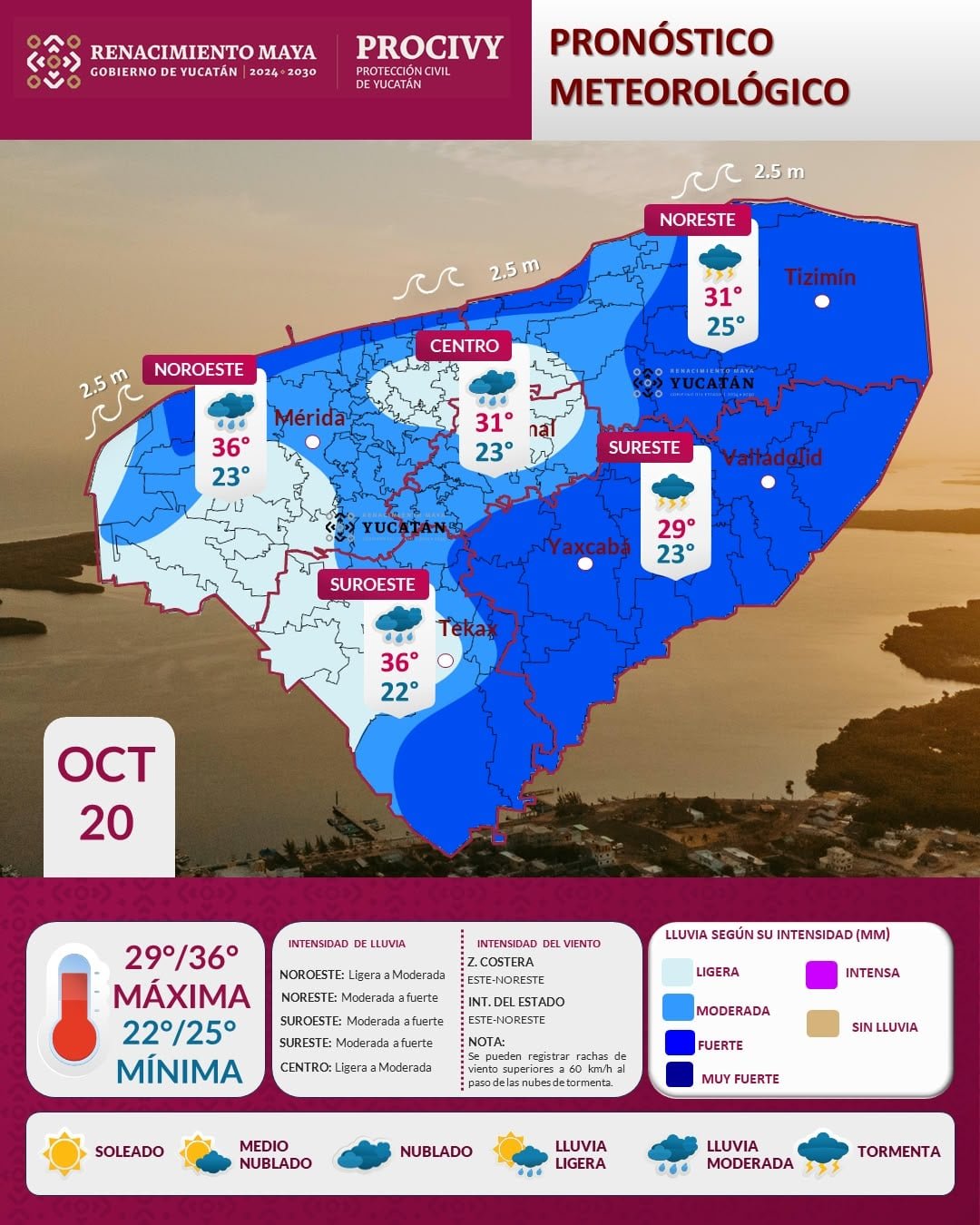
Mérida, Yucatán — A stationary front sitting north of the Yucatán coast will begin to dissipate, but its remnants, an influx of moisture and daytime heating will still combine to bring rain across much of the state on Tuesday, forecasters said.
Light to moderate rain is expected along the coast and in the northeast — including Tizimín and neighboring municipalities — between 9 a.m. and 11 a.m.
From midday, the rain will spread to towns in the center and southeast of the state. After 1 p.m. it will reach the southwest and northwest, including Mérida and the rest of the capital region.
Heat, gusty winds and rough seas
- Temperatures: Warm to hot, with highs of 29–31°C in the east, 34–36°C in the west and 30–32°C along the coast.
- Winds: Easterly in the morning shifting to northeasterly in the afternoon at 15–30 km/h, with gusts above 60 km/h in areas of rain.
- Surf: Waves of about 2.5 meters are expected along the Yucatán coastline.
Officials advised residents in areas expecting heavy downpours to take precautions against strong gusts and standing water on roads.
More Environment
- Cancún to Host Climate Change Colloquium With Experts From Mexico, Guatemala and New York
- Tulum Records Over 6,000 Sea Turtle Nests as Beach Furniture Threatens Hatchlings
- Lab Coral Restoration Urgent as Caribbean Reefs Decline, Expert Warns
- Quintana Roo Bolsters Sargassum Strategy With Satellite Monitoring and Research
- Documentary on Puebla River Defenders Screens Free in Cancún
More Quintana Roo
- Mara Lezama Hands Out 100 Sewing Machines in Chetumal to Boost Women’s Self-Employment
- Tourism Slump Forces 35% of Skål México Businesses to Borrow to Cover Payroll
- Crystal Meth Addiction Surges in Quintana Roo, Fuels Nearly 90% of Homicides
- Quintana Roo Leads Yucatan Peninsula in Rape and Sexual Abuse Cases
- Orionid Meteor Shower to Peak Over Mexico on Oct. 21-22