
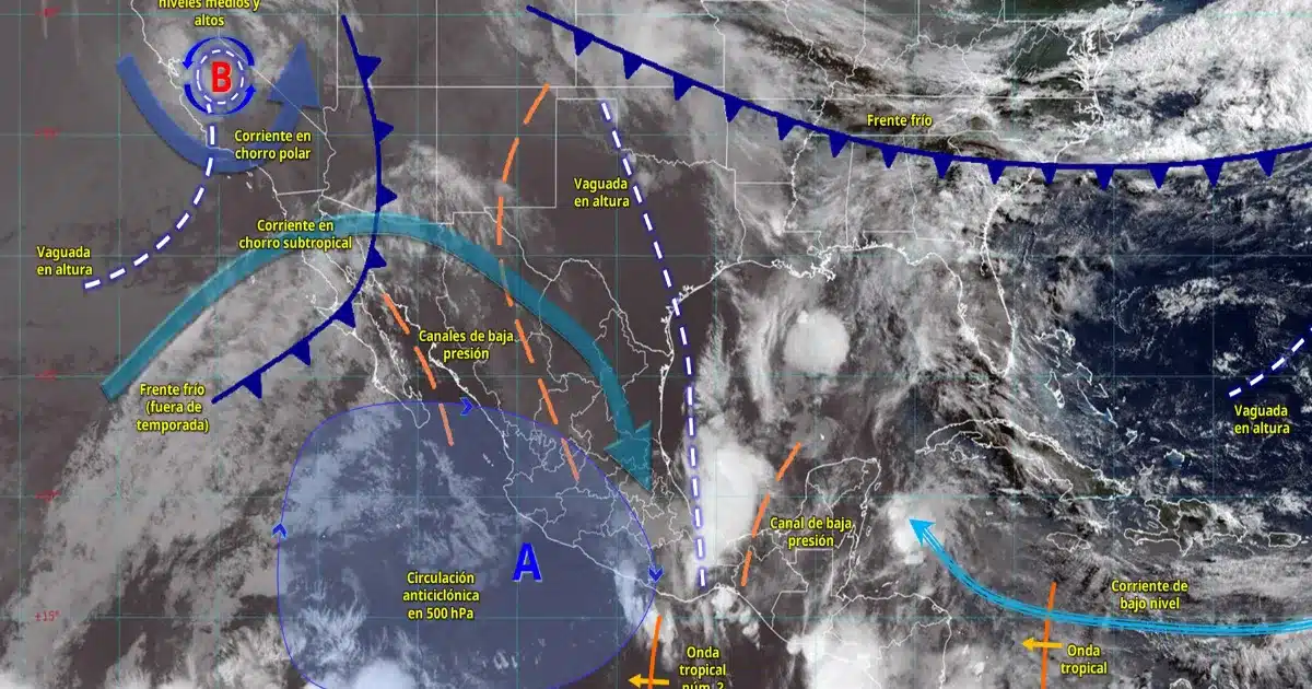
Mexico City — A tropical wave moving over southern Oaxaca and Guerrero, combined with moisture from the Gulf of Mexico and the Caribbean Sea, will bring intense rainfall to several southeastern states on Thursday, according to Mexico’s National Meteorological Service (SMN).
The hardest-hit states will be Chiapas, Tabasco, Campeche and Yucatan, where the SMN forecasts intense precipitation. Very heavy rain is expected in Veracruz, Oaxaca and Quintana Roo, while Puebla and Guerrero will see heavy downpours.
Authorities warned that the conditions could cause flooding, landslides and rising river and stream levels, urging residents to stay informed and take precautions.
Quintana Roo: Very Heavy Rain and High Waves
In the Yucatan Peninsula, skies will remain mostly cloudy through the day, with hot weather and a lingering heat wave in parts of Campeche and Yucatan.
Quintana Roo will see very heavy rain, especially in the eastern, western and southern regions, accompanied by lightning and wind gusts up to 60 km/h (37 mph).
The SMN also warned of waves 1.5 to 2.5 meters (5 to 8 feet) high along the coasts of Quintana Roo and Yucatan, which could affect maritime and tourist activities.
Heat Wave Persists Across Much of the Country
Despite the rain, hot to very hot weather will continue across most of Mexico. The heat wave will affect states including Sinaloa, Nayarit, Jalisco, Colima, Michoacan, Guerrero, Oaxaca, Chiapas, Campeche and Yucatan.
In central Mexico, including Mexico City and the State of Mexico, afternoon showers with lightning and possible hail are expected, with highs near 28°C (82°F).
In the north and northwest, an out-of-season cold front and jet streams will generate strong winds and dust storms in Baja California, Sonora, Chihuahua, Coahuila and Zacatecas. Isolated showers are also possible in parts of Baja California, Nuevo Leon, San Luis Potosi and Tamaulipas.
More Lifestyle
- Cancún Opens Registration for Janal Pixan 2026 Catrina and Altar Contests
- Brain-Eating Amoeba Found in Six Artificial Lakes in Mérida; Water Contact Restricted
- Cancún Launches 2026 Ocular Prosthetics Program With Free Evaluations
- Playa del Carmen Health Center in Villas del Sol to Close Two Days for Maintenance
- Tulum’s Mureco Museum Adds 53 Archaeological Pieces From Across Mesoamerica
More Quintana Roo
- Mexican Caribbean Courts Convention Business at Las Vegas Trade Show
- Heavy Rains to Soak Quintana Roo as Unstable Weather Moves In
- Ten Rural Communities in Quintana Roo Form Community Conservation Territories
- Study Finds Cancún’s Laguna Manatí Mangrove Could Qualify for Carbon Credits
- Lawmakers Seek to Make Mexican Sign Language Mandatory in Quintana Roo Schools