
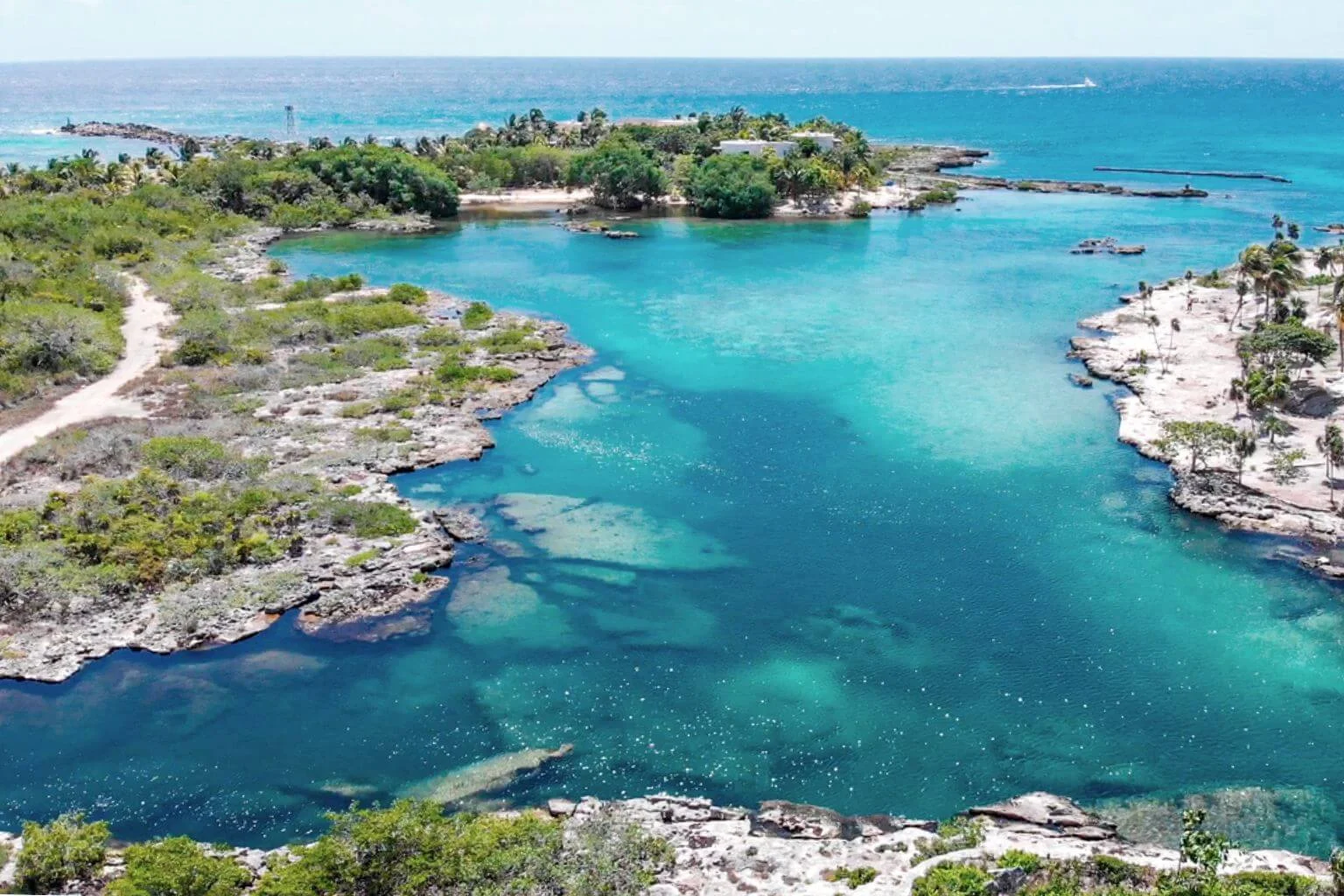
Puerto Aventuras, Quintana Roo — A new hotel and residential development proposed for one of the remaining undeveloped coastal parcels in Puerto Aventuras’ Fase 4 is seeking federal environmental authorization, drawing renewed attention to the area’s expansion and its previous history with environmental authorities.
The project, called Puerto Aventuras Luxury Resort, is being promoted by Banco Santander México in its capacity as trustee, or fiduciary, for Puerto Aventuras. According to its Environmental Impact Statement, known in Mexico as a Manifestación de Impacto Ambiental or MIA, the development would occupy approximately 4.67 hectares divided among three lots on the Caribbean coastline.
For local residents, one point of terminology deserves clarification. Federal environmental and planning documents refer to the broader development area as “Plano 4,” while Puerto Aventuras residents commonly know it as Fase 4. This is not a new name for the proposed resort, nor is Fase 4 itself an undeveloped area. Much of Fase 4 already has roads, water and electricity infrastructure, private homes and condominium complexes. The new proposal concerns a specific, largely undeveloped waterfront parcel within that established section of the community.
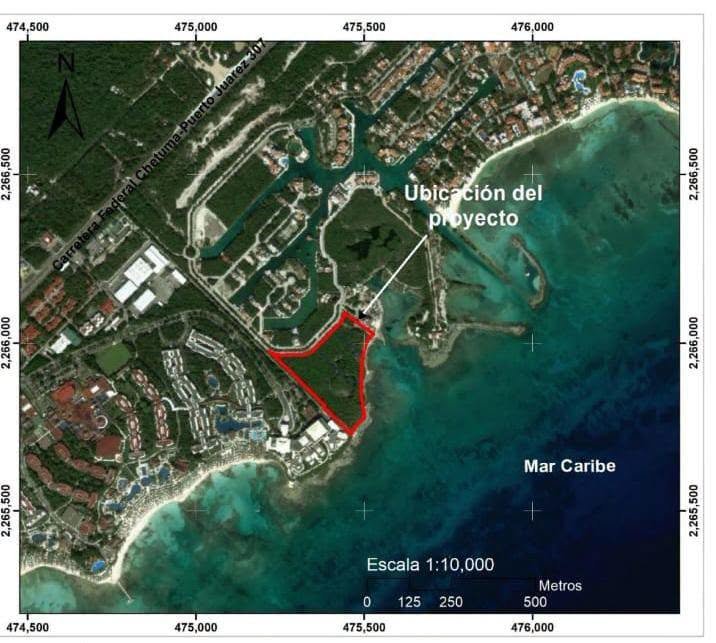
Project maps place the site immediately south of the existing marina area and directly north of the Barceló resort complex, on a prominent triangular parcel fronting the Caribbean Sea.
A 194-Unit Resort, Not a 2,000-Room Hotel
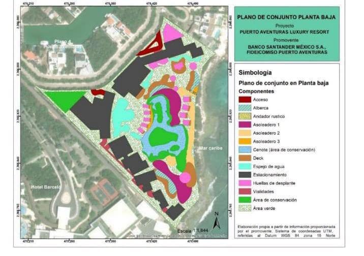
The current proposal calls for 73 residential apartments and 121 hotel rooms, distributed among seven principal buildings. The site plan also shows villas, three swimming pool areas, decks, internal water features, pedestrian paths, landscaped areas, parking and access roads.
The estimated investment is 900 million pesos, with one percent of that amount, approximately 9 million pesos, designated in the environmental filing for prevention, mitigation or compensation measures.
The distinction between this specific project and the broader development plan is important. Puerto Aventuras Luxury Resort itself is not a 2,000-room development.
Rather, the 194-unit project sits within a much larger planning framework for the broader area formally referred to in environmental documents as Plano 4. That master plan contemplated the subdivision of approximately 46.9 hectares into 122 lots, with a maximum overall capacity equivalent to 2,000 hotel rooms across all of them.
According to the environmental documentation, those 122 lots include 110 designated for tourist-residential use, five for mixed tourism, five for condominium tourist-residential development and two for mixed tourist-commercial use.
The broader plan identified approximately 231,300 square meters, or 49.31 percent of the property, for development, while about 237,783 square meters, or 50.7 percent, were designated as conservation areas.
Individual buyers or developers of those lots are expected to seek their own environmental authorization when required. In other words, approval of the larger urbanization plan does not automatically grant permission to construct every hotel, condominium or commercial project contemplated within it.
Puerto Aventuras Luxury Resort is one such individual project now going through that process.
Cenote and Conservation Areas Included in the Site Plan
The project’s maps provide a clearer picture of the environmental features of the 4.67-hectare site.
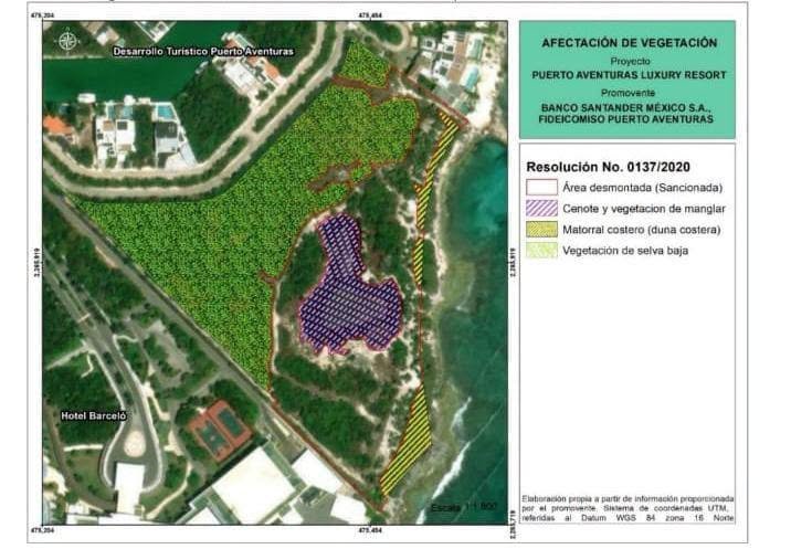
They identify several vegetation types, including low jungle vegetation, coastal scrub associated with the dune system and mangrove vegetation around a cenote.
The current development plan identifies the cenote itself as a conservation area. The proposed layout shows it surrounded by landscaped open space and a substantial internal water feature, with the hotel buildings, villas, pools and other infrastructure arranged around different parts of the property.
That detail is significant in the Riviera Maya, where cenotes, mangroves, coastal dunes and groundwater systems are closely interconnected and can become central considerations during the federal environmental review process.
Maps Identify a Previously Cleared and Sanctioned Area
The project’s environmental history is also clearly visible in the maps included with the documentation.
One map specifically identifies a portion of the site as “Área desmontada (Sancionada),” or “Cleared area (sanctioned),” and references PROFEPA Resolution No. 0137/2020.
The current MIA also acknowledges an earlier administrative proceeding by Mexico’s Federal Attorney for Environmental Protection, PROFEPA, under case number PFPA 29.3/2C.27.5/0078-19.
The resolution associated with that proceeding is dated December 17, 2019.
Publicly available records provide additional context. On September 10, 2019, federal environmental authorities imposed a closure on construction activities in the federal maritime-terrestrial zone and marine area of the Chac-hal-al inlet in Plano 4 of Puerto Aventuras, after those responsible reportedly failed to demonstrate that they had the necessary environmental authorization or exemption for the works being carried out.
The project maps now make the connection between the property and prior enforcement more concrete by identifying the specific portion of land that had been cleared and sanctioned.
However, it is important not to overstate what the available documents prove. The records reviewed do not establish that the exact seven-building Puerto Aventuras Luxury Resort project now being proposed is identical to the work that triggered the 2019 enforcement action. What is clear is that the current project site has a documented environmental enforcement history and that the new MIA expressly acknowledges it.
Part of a Long-Planned Expansion
Development plans for this southern portion of Puerto Aventuras are not new. Federal environmental records show that a broader expansion involving what documents call Plano 4 was under consideration at least as far back as 2005, when environmental filings for the consolidation of the Puerto Aventuras nautical and residential tourism development included this area within future growth plans.
Over the years, portions of what residents know as Fase 4 have been developed with homes, condominium projects, roads and utilities. The parcel now proposed for Puerto Aventuras Luxury Resort is one of the more conspicuous remaining undeveloped waterfront sections.
That distinction matters because describing all of Fase 4 as an undeveloped future expansion zone would be inaccurate. The current proposal is better understood as a substantial new resort project on a specific undeveloped coastal property within an already established and partially built-out section of Puerto Aventuras.
What Happens Next?
Submission of an environmental impact statement does not mean the project has been approved. SEMARNAT, Mexico’s Secretariat of Environment and Natural Resources, must evaluate the proposal and its possible impacts. The agency may approve it, approve it with conditions, request additional information or reject it.
For a coastal Riviera Maya project containing low jungle vegetation, coastal scrub, mangroves and a cenote, the review may include questions surrounding vegetation removal, wildlife habitat, drainage, wastewater, groundwater, coastal impacts and compliance with applicable land-use and environmental regulations.
The project’s previous enforcement history is likely to make the review particularly interesting to local residents.
Puerto Aventuras Luxury Resort is proposed as a 73-apartment, 121-room hotel and residential development on 4.67 hectares of waterfront land in the area locally known as Fase 4. The site contains a cenote designated for conservation, several distinct vegetation types and a portion previously identified as having been cleared and sanctioned by federal environmental authorities.
The much larger figure of 2,000 rooms refers to the broader master plan covering 122 lots, not to this single resort.
For Puerto Aventuras residents, that distinction is important. So is the location. This is not a distant future expansion somewhere beyond the existing community. It is a significant new proposal for one of the remaining undeveloped parcels along the Caribbean coastline within Fase 4 itself.
More Local News
- Hundreds of Riders Expected for Tulum’s Fourth Federated Horseback Ride
- Quintana Roo Riders Resume ‘Vest Law’ Talks, No Protests
- Cancún Residents Demand Governor’s Intervention Over Alleged Land Fraudster
- Quintana Roo Plans Two Wastewater Plants and Two Aqueducts for Cancún and Playa del Carmen
- Playa del Carmen Ranks Second in HIV Cases in Quintana Roo, Official Says
More Puerto Aventuras
- Sargassum Barrier Reaches Puerto Aventuras as Navy Support Takes Shape
- Dolphin Swims Continue in Puerto Aventuras as Cancún Dolphin Debate Simmers
- Seven Arrested in Puerto Aventuras Taxi Extortion Ring Bust
- Gunmen Shoot Up BBVA Bank Branch in Puerto Aventuras, Quintana Roo
- Prosecutors Raid Home in Puerto Maya, Puerto Aventuras
