
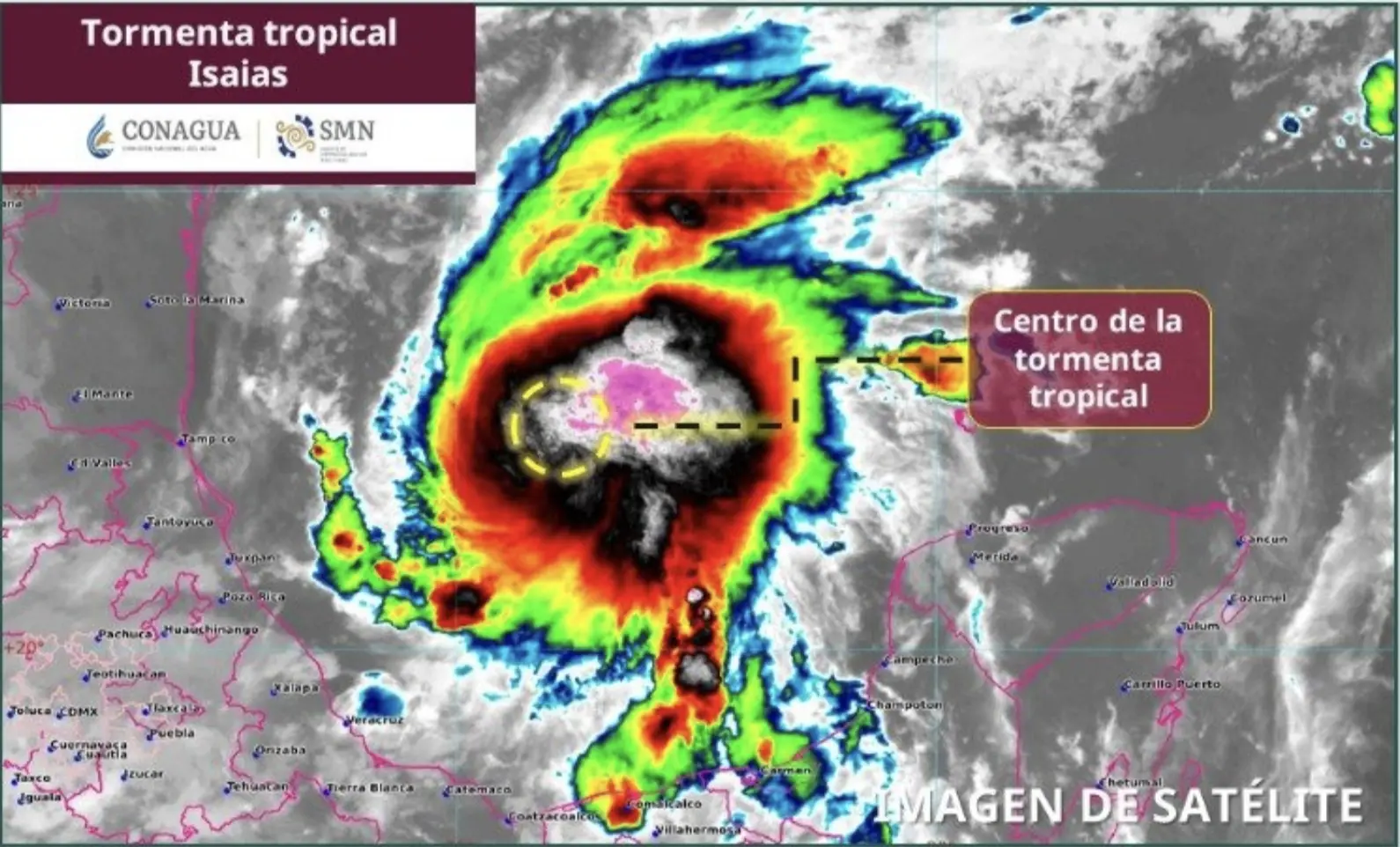
Gulf of Mexico — Tropical Storm Isaias formed in the Gulf of Mexico on Oct. 7, 2026, after strengthening from Tropical Depression 9, and is now tracking toward the United States, where forecasters expect it to come ashore as a Category 2 hurricane.
Current Conditions
Isaias was packing sustained winds of 65 km/h (40 mph) with higher gusts, according to the National Hurricane Center (NHC). In its morning bulletin, the NHC placed the storm’s center over open waters in the southwestern Gulf, where it continues to draw on warm ocean temperatures.
- Location: 460 km (about 285 miles) west of Progreso, Yucatán, and 935 km (about 580 miles) southwest of the mouth of the Mississippi River.
- Wind speed: Maximum sustained winds of 65 km/h (40 mph), with stronger gusts.
- Movement: East-northeast at 13 km/h (8 mph).
Forecast Track
Forecasters expect Isaias to reach hurricane strength by Oct. 8 before striking the U.S. Gulf Coast over the weekend. Warm waters are expected to fuel rapid intensification, and NHC models have flagged a critical 72-hour window for emergency preparations as sea and weather conditions deteriorate.
Mexico Activates Precautions
Veracruz, Tamaulipas and the Yucatán Peninsula have activated preventive protocols, with rainfall of up to 75 mm (about 3 inches) and waves exceeding three meters (roughly 10 feet) in the forecast. Although the storm’s center is not expected to make direct landfall on Mexico’s coast, its outer rain bands are raising the risk of flooding and landslides along the eastern seaboard and the peninsula.
- Veracruz: Civil protection officials issued a Grey Alert and deployed more than 500 emergency workers, with 50 to 75 mm (2 to 3 inches) of rain expected over already saturated ground.
- Tamaulipas: Authorities are monitoring reservoirs and urban drainage systems as new storm bands converge with earlier rainfall.
- Yucatán Peninsula: Electrical storms and moderate to heavy rain are forecast for Campeche, Yucatán and Quintana Roo.
- Maritime restrictions: Port captains have ordered closures because of winds above 60 km/h and waves of 2 to 3 meters.
Emergency Declarations in the United States
Florida Governor Ron DeSantis declared a state of emergency in 25 counties through Executive Order 26-202, covering the Panhandle and Big Bend regions, as Isaias approaches with sustained winds of up to 175 km/h (about 110 mph). Louisiana, Mississippi and Alabama are preparing hurricane and storm surge watches.
How to Prepare
- Monitor official sources: Follow bulletins from Mexico’s National Meteorological Service (SMN) and the U.S. National Hurricane Center (NHC).
- Stock emergency supplies: Keep enough drinking water, non-perishable food, reserve medication and independent lighting for at least 72 hours.
- Secure buildings: Install protective panels on windows and move machinery or vehicles to higher ground.
- Safeguard documents and plan evacuation routes: Store important records in waterproof or digital form and confirm the location of assigned shelters in advance.
More Environment
- Cozumel to Host 18th Island Bird Festival Oct. 7-11
- MarAlliance Launches Free MARAP App to Track Marine Wildlife in the Mexican Caribbean
- Playa del Carmen Seeks Million-Dollar Investment for Sargassum Processing Plants
- Yucatán Officials Rule Out More Brain-Eating Amoeba Infections at Mérida’s Plaza La Isla
- Cozumel Tightens Crocodile Response Protocols After Sightings