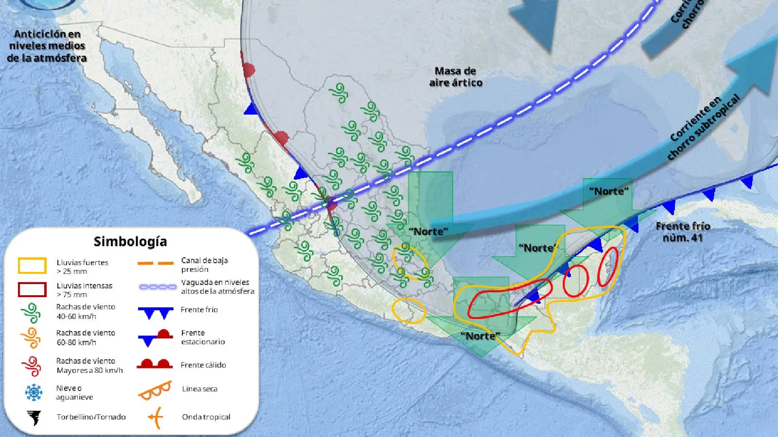
Cancún, Quintana Roo — Cold Front 41 will generate heavy to intense rainfall, wind gusts up to 80 km/h, and high waves across Quintana Roo on Tuesday, according to the National Meteorological Service and the State Civil Protection Coordination.
The frontal system is moving over the Yucatan Peninsula, causing cloudy skies, thunderstorms, and rainfall accumulations between 75 and 150 millimeters. These conditions could lead to puddles and flooding in various areas of the state.
The arctic air mass associated with the system will also trigger a strong “Norte” event, with northeast winds of 60 to 80 km/h in coastal zones and waves up to 3.5 meters, primarily along the coasts of Campeche, Yucatan, and Quintana Roo.
Municipalities Affected by Rain and Thunderstorms
Between 7:00 and 10:00 a.m., meteorological authorities forecast showers and rain with electrical discharges in several municipalities of the state.
Areas with the highest probability of precipitation include:
- Benito Juárez (Cancún)
- Puerto Morelos
- Isla Mujeres
- Playa del Carmen
- Tulum
- Cozumel
- Felipe Carrillo Puerto
- José María Morelos
- Bacalar
- Othón P. Blanco
- Lázaro Cárdenas
Authorities recommend staying alert to meteorological bulletins and official notices, as conditions may vary throughout the day.
Weather Forecast for Major Tourist Destinations
The forecast indicates the environment will remain mild in the morning and warm during the day, with maximum temperatures between 25 and 29 degrees Celsius in most municipalities.
Cancún (Benito Juárez)
- Maximum temperature: 26 to 28 °C
- Thermal sensation: 29 °C
- Northeast winds of 35 to 45 km/h, with stronger gusts
- Rain with electrical activity
Playa del Carmen
- Maximum temperature: 26 to 28 °C
- Thermal sensation: 29 °C
- Intermittent showers and thunderstorms
- Winds up to 45 km/h
Tulum
- Maximum temperature: 26 to 28 °C
- Thermal sensation: 29 °C
- Heavy rain and cloudy skies
Cozumel
- Maximum temperature: 25 to 27 °C
- Thermal sensation: 30 °C
- Wind gusts up to 60 km/h
High Waves and Navigation Precautions
The Norte event will also generate waves between 2 and 3.5 meters, increasing up to 12 feet in the Yucatan Channel and Quintana Roo coasts, posing risks for maritime activities.
Authorities recommend that fishermen, tourism service providers, and the general public consult Port Captains before undertaking activities at sea.
Sea temperature remains between 25 and 27 degrees Celsius, while atmospheric pressure hovers around 1013 hectopascals across most of the state.
Civil Protection Recommendations
The Quintana Roo State Civil Protection Coordination urged the population to stay informed and take preventive measures given the meteorological conditions.
Key recommendations include:
- Constantly consult official meteorological bulletins
- Exercise extreme caution while driving, especially due to possible fog banks
- Protect minors, older adults, and people with respiratory illnesses from temperature changes
- Avoid maritime activities if Port Captaincy restrictions exist
Authorities also encourage prioritizing safety and following official instructions while the frontal system effects persist.
National Context: Torrential Rains and Cold in Various Regions
Nationally, Cold Front 41 will also cause torrential rains in southern Tabasco and northern Chiapas, while the associated arctic air mass will bring cold to very cold conditions across much of the country during early morning hours.
In contrast, the National Meteorological Service indicated a heat wave will continue in Pacific states like Jalisco, Colima, Michoacán, Guerrero, Oaxaca, and Chiapas, where elevated temperatures will persist.
Discover more from Riviera Maya News & Events
Subscribe to get the latest posts sent to your email.