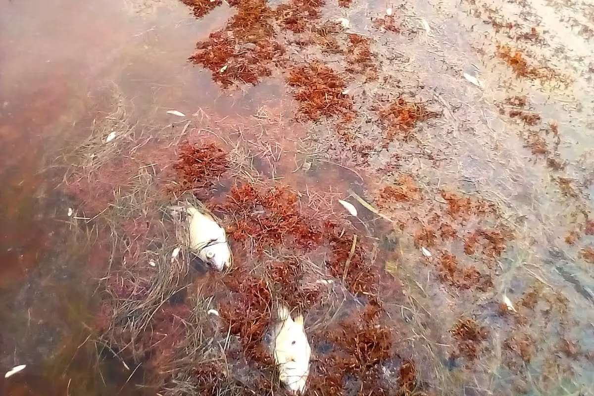
Xcalak, Quintana Roo — Residents of this remote fishing village on Mexico’s southern Caribbean coast are raising an environmental alarm over weeks of accumulated sargassum, saying the rotting seaweed is killing fish, fouling the water and threatening the local economy.
Sergio Beltrán Ojeda, a representative of the community’s delegational committee, said the macroalgae has remained piled on the shore for weeks, degrading water quality and harming marine life. He called on the Mexican Navy (SEMAR) to provide more support to address the problem.
As the seaweed decomposes, it consumes dissolved oxygen in the water and releases organic matter that alters the ecosystem, Beltrán Ojeda explained. In the areas where it concentrates, the breakdown can produce substances such as hydrogen sulfide, a gas with a smell resembling rotten eggs.
According to Beltrán Ojeda, the damage shows up in the water’s color and turbidity — conditions that harm fish, crustaceans and other species that need adequate oxygen levels to survive.
Among the most visible signs of deterioration, he cited the appearance of dead fish, which he attributed to reduced oxygen and declining water quality. He warned that the harm can go unnoticed until marine life is already affected.
The community representative said the Navy’s sargassum removal efforts are concentrated mainly in Mahahual, leaving Xcalak without sufficient institutional support for the volume of seaweed reaching its shores.
He also questioned the lack of attention from Navy personnel assigned to the area and said the amount of accumulated sargassum has exceeded residents’ ability to respond.
Beltrán Ojeda asked authorities to consider the community’s needs and step up efforts to clear the seaweed, noting that Xcalak depends on fishing and tourism — activities tied directly to the area’s environmental conditions.
Xcalak sits at the southern end of the Costa Maya in the municipality of Othón P. Blanco, near the border with Belize. It occupies a strip of land between the Caribbean Sea and a coastal lagoon, roughly 55 kilometers (34 miles) south of Mahahual and about 130 kilometers (81 miles) by road from Chetumal.
More Environment
- Deer at Calle 88 Raises Alarm Over CFE Cozumel Cable Plan
- Yucatán Leads Mexico’s Octopus Production With More Than 28,000 Tons
- Mexico Seizes Three Boats at Arrecife Alacranes Over Illegal Activities
- Pink Flamingos Find Refuge in Cancún’s Nichupté Lagoon, Officials Say
- Hurricane Isaias Disrupts Water Sports Services in Playa del Carmen