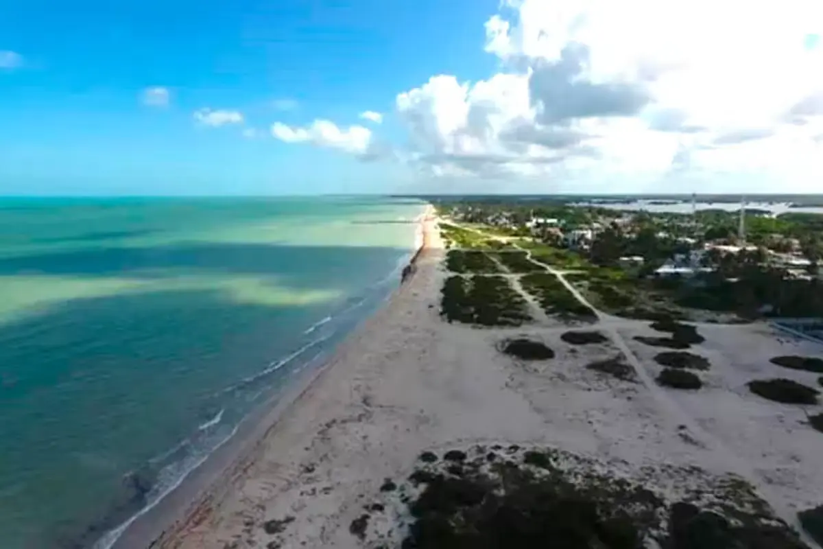
Progreso, Yucatan — Where white sand beaches and palm trees once lined the Gulf coast, sharp rocks, debris, and waves crashing directly against seawalls now dominate the landscape. Coastal erosion in Yucatan has accelerated dramatically over the past eighteen months, swallowing dozens of meters of beach in Progreso, Chelem, Chicxulub Puerto, Telchac, and Dzilam de Bravo.
This isn’t a sudden natural disaster but the result of at least four decades of human decisions that disrupted the natural dynamics of one of Mexico’s flattest and most vulnerable coastlines. Scientists from UNAM, Cinvestav Mérida, Cicese, and international organizations like NASA agree: the Yucatan coast is in crisis, and temporary fixes aren’t enough.
The Pier That Changed Everything
To understand what’s happening to Yucatan’s coast, one must go back to 1985 when then-Governor Víctor Cervera Pacheco pushed to extend Progreso’s fiscal pier to 6.5 kilometers, making it one of the world’s longest to accommodate cruise ships and deep-draft vessels.
While economically successful—Progreso Port is now the main entry point for goods in the Yucatan Peninsula—the structure proved disastrous for coastal dynamics. Joint research by NASA and the Center for Scientific Research and Higher Education of Ensenada (Cicese) confirmed through Landsat 8 satellite images that the pier interrupts the natural sediment flow that coastal drift currents transport from east to west along the shoreline.
Researcher Gabriela García Rubio of Cicese explains that the pier’s remote terminal—built as rock fill rather than with arches like the original section—completely blocks current passage. This creates what oceanographers call “drift accretion and drift erosion”: artificial sand accumulation in some areas and severe loss in others, particularly in Chelem, Chicxulub, and Progreso’s traditional seawall.
The federal government acknowledged this in December 2021, admitting in official documents that the pier creates a sediment transport gradient along more than seven kilometers, with visible erosion in the first six kilometers after Yucalpetén’s Port of Refuge. Despite this recognition, port expansion continued.
Dredging That Accelerated the Crisis
On January 11, 2025, the dredge Fernando de Magallanes began work off Progreso’s coast. According to testimonies from seawall merchants and court documents, erosion dramatically accelerated at the traditional seawall—the area most frequented by tourists and supporting over a thousand direct workers—starting from that date.
By September 2025, erosion reached the international seawall. By March 2026, economic impact became palpable: fewer visitors, shorter stays, and falling income.
An indirect injunction filed by environmental defenders documents serious irregularities in the project: the authorized Environmental Impact Statement covers only 40 hectares, but the actual work spans 80 without additional evaluation. The filers argue violations of environmental laws and the Escazú Agreement. Coastal property owners are considering suing the Mexican state for patrimonial responsibility.
A Coastline Devoured in Four Decades
The numbers speak for themselves. Between 1980 and 2019, the Yucatan coastline lost an average of 19 meters of beach along its entire length. Researcher Jorge Euán, who has documented the phenomenon for decades, has detected retreats of up to six meters per year in high-risk zones like Chelem, Chuburná, and Chicxulub. In Telchac Puerto, satellite images show retreats of up to 100 meters inland in some areas.
After Hurricane Milton in October 2024—which altered Gulf marine currents despite not making landfall in Yucatan—and due to the local “chikin ic” phenomenon, Progreso lost up to 20 additional meters of beach in just weeks. The Semarnat delegation in Yucatan acknowledged in January 2026 that the problem isn’t limited to Progreso: “We can’t particularize Progreso, Telchac, or Dzilam. No. It’s the entire coast,” stated delegate Guillermo Humberto Porras Quevedo.
Twenty-seven percent of Yucatan’s coastal strip has homes built less than 10 meters from the sea, according to the Mexican Association of Real Estate Professionals. This accelerated real estate development—with condominiums that eliminated dunes and cleared mangroves—destroyed the natural barriers that protected beaches from wave impact for centuries.
In Chicxulub Puerto, where the beach near the pier has practically disappeared, only sharp rocks remain, posing constant danger to swimmers.
Remedies That Don’t Cure
Facing the advancing sea, municipal and state authorities have responded with emergency measures that specialists call palliatives. In December 2025 and early 2026, construction workers placed giant sandbags along Progreso’s seawall. In October 2025, the municipality installed geotubes—large geotextile cylinders filled with sand—from the Inclusive Beach to the tourist letters on the seawall.
The problem, researchers say, is that these works don’t address the cause. Oceanographer Christian Appendini, former coordinator of UNAM’s Sisal Academic Unit, notes that improvised containment structures interrupt natural sediment transit and create accumulation in one spot while eroding adjacent beaches.
“Visitors will see beach for a time, but when they return months later, the sand will be gone,” he warns. Monitoring by UNAM between Progreso and Telchac confirmed that groynes built to retain sand in one area ended up destroying neighboring beaches.
In the first 16 kilometers east of Progreso’s pier, more than 400 “coastal protection” structures built by private parties without engineering basis have been identified: wooden groynes, stacked rocks, concrete walls, artisanal geotubes. Each, according to experts, transfers the problem to neighbors’ properties.
Yucatan’s Secretary of Sustainable Development, Neyra Silva Rosado, has stated that most are irregular and violate environmental beach regulations, but their removal has been slow and ineffective. In 2023, the budget for specific actions against coastal erosion in Yucatan was just 674,000 pesos—less than 12 percent of what experts consider necessary for a minimally effective program.
The state government has spent about 50 million pesos on conservation and fill works in recent years without lasting results. The only solution mentioned by all consulted experts—an artificial sediment bypass or transfer system replicating the natural flow interrupted by the pier—requires million-dollar investment and political will that hasn’t materialized.
The Ecosystem Also Loses
Erosion doesn’t just erase beaches: it erases ecosystems. In Chelem Puerto during 2025, at least two cases were documented of sea turtles that came ashore to nest but returned to sea without completing their reproductive cycle: compact sand mixed with debris makes nesting impossible. In Progreso, turtles only manage to dig 10 centimeters or less before giving up.
In Chicxulub, fishermen’s boats remain exposed to waves because no beach arc exists to shelter them; during northerly wind seasons, many vessels suffer damage or become unusable.
Dunes—which act as natural sand reservoirs and first-line defense against cyclones—have disappeared along most of the coastline between Progreso and its communities. Mangroves, which absorb wave impact and serve as nurseries for dozens of marine species, have been cleared for housing developments. Both natural barriers, once eliminated, take decades to recover.
Climate change turns a serious problem into a potentially irreversible one. NASA and UN projections estimate sea levels could rise nearly one meter by 2100. For Yucatan’s coastline—flat, without cliffs, with minimal slopes—that increase would have devastating consequences.
Discover more from Riviera Maya News & Events
Subscribe to get the latest posts sent to your email.